The transformation of Toronto’s Port Lands represents one of North America’s most ambitious urban renewal projects, with climate resilience at its core. Once an industrial wasteland, this 800-acre stretch along Lake Ontario now stands as a monument to forward-thinking infrastructure planning—designed specifically to withstand catastrophic flooding events that could rival or exceed Hurricane Hazel, the devastating 1954 storm that claimed 81 lives across Ontario.
“What we’ve accomplished here is nothing short of revolutionary,” explains Jennifer Keesmaat, Toronto’s former chief planner. “We’ve created a neighborhood that doesn’t just accommodate water—it embraces it as part of the urban fabric.”
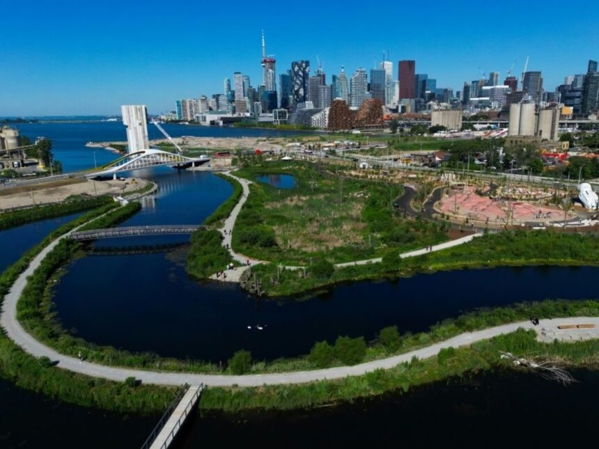
The $1.25 billion project’s centerpiece is a re-engineered Don River mouth that now flows through a naturalized valley, complete with expansive wetlands designed to absorb and channel floodwaters safely into Lake Ontario. This engineering marvel can handle water volumes from a regulatory storm—a hypothetical event that combines Hurricane Hazel’s rainfall with the worst possible conditions.
Prior to reconstruction, over 290 hectares of prime downtown-adjacent land sat vulnerable to catastrophic flooding. The Port Lands Flood Protection Project has unlocked this potential while simultaneously creating Villiers Island—Toronto’s first climate-positive community, where parks and green spaces comprise nearly half the land area.
During a recent media tour, officials demonstrated how the reimagined landscape functions not just as flood protection but as vital city infrastructure. The new river valley, flowing through what was once industrial hardscape, can handle 15 million cubic meters of water during extreme weather events—channeling it safely away from densely populated areas.
What makes this project particularly noteworthy is its multifaceted approach to climate resilience. Beyond flood protection, the redevelopment incorporates habitat restoration, creating shelter for over 180 species of birds and wildlife. The soil remediation process alone—cleaning decades of industrial contamination—stands as one of Canada’s largest environmental cleanup efforts.
“The Port Lands represent a new model for urban development in the climate change era,” says Julie Dabrusin, Parliamentary Secretary to the Minister of Environment and Climate Change. “We’re not just protecting against yesterday’s storms—we’re preparing for tomorrow’s climate reality.”
The economic implications are equally significant. The redevelopment is expected to generate over $5.1 billion in value, creating space for 25,000 residents and 30,000 jobs. Waterfront Toronto estimates the project will deliver $1.9 billion in economic benefits to the Canadian economy, demonstrating how climate adaptation can drive economic growth.
Critics have questioned the project’s substantial cost, but defenders point to the catastrophic price tag of inaction. Hurricane Hazel caused damage equivalent to over $1 billion in today’s dollars. Recent flooding events in Calgary (2013) and eastern Canada (2017, 2019) have demonstrated how climate-related disasters can quickly overwhelm unprepared infrastructure.
As cities worldwide grapple with increasingly unpredictable weather patterns, Toronto’s Port Lands stands as a case study in proactive climate planning. The question remaining for other waterfront cities isn’t whether they can afford similar infrastructure investments, but whether they can afford not to make them as our climate continues to change.